 |
St. Peter's Lane
|
|
|
An archaeological evaluation in advance of proposed development of the St Peter's Lane frontage of the Pound Lane car park was undertaken in September, 1993 with some useful results. The site lies in the northern quarter of the walled city between the two branches of the River Stour at an elevation of about 8 m. 0.0., opposite medieval Blackfriars. The trench was cut at right-angles to the St. Peter's Lane street frontage and was designed to reveal the nature, quality, date and depth of the archaeological sequence. From the available documentary evidence it would seem that this part of the city was largely open land for many centuries. The first edition, 1:500 Ordnance Survey dated 1874 shows the area occupied by glass-houses, planted trees and pathways. Eighteenth-century maps show very similar arrangements with orchards and garden plots clearly visible.
Outside the cellar, below the tarmac and hardcore of the present car park, lay an extensive deposit of dark grey-brown loam probably representing a buried topsoil. This soil layer contained late nineteenth-century pottery and sealed a deposit of compact clay loam containing large amounts of slag and clinkerwhich was confined to the north-eastern side of the trench and had every appearance of being a rough metalling, perhaps the pathway shown on the 1874 survey. Late nineteenth-century pottery was recovered from its make-up. Below the metalling was a very thick deposit of evenly textured dark grey-black clay loam containing pot sherds dated c. 1475-1525. Without doubt this layer represents a deep garden soil of post-medieval date that can be readily equated with the horticultural activities indicated on early surveys. Below this garden soil were three deposits of grey gritty clay loam with frequent rolled flints. Although these contained significant quantities of medieval pottery dated c. 1175-1250, the latest sherds are dated 1475-1525. Animal bone and shell was also recovered. It seems likely that the overlying garden soil was created by continual working of these deposits. The origin of the lower layers is not certain. The large quantities of water-rounded flints that they contained are clearly derived from the local river gravels but it seems more likely that the deposits themselves represent deliberately dumped material rather than being water-laid. They could well represent an attempt at consolidating a low-lying wet area. That this was then the nature of the ground here is clearly demonstrated by the underlying deposit which comprised a continuous layer of dark brown organic peat between 0.22 and 0.36 m. thick. This peat layer was waterlogged but was found to be largely devoid of artefacts, although a few sherds of pottery dated c. 1000-1100 were recovered together with a fragment of leather, perhaps part of a shoe. The top of the peat had clearly once formed a well-defined surface. In the central part of the trench, a row of over twenty pointed wooden stakes running roughly east-west represented the base of an old fence line, whose upper levels had subsequently been eroded off; this quite possibly represents part of some kind of animal compound and suggests the use of the area as pasture. The stakes were left in situ and have been carefully buried. Further to the south-east, at the end of the trench a well-preserved wooden hurdle was found lying flat on the surface of the peat, under the concrete floor of the modern cellar. The hurdle, 0.40-0.50 m. in width, aligned roughly parallel to St Peter's Lane, was probably deliberately placed here to form a walk-way across the wet peat surface. Some ten sherds from a large pottery vessel were found lying on the surface of the hurdle at its eastern end. These have been dated to the period c. 1075-1200.
Underlying the organic loam deposit was a thick layer of water-laid grey-brown organic clay which produced a small quantity of Roman pottery and tile together with occasional animal bones. This rested upon natural flint river gravel which was at least 0.25 m. thick and sloped away to the south-east (i.e. towards the modern river channel at Blackfriars). The general sequence on the site is thus fairly straightforward, with water-laid Roman sediments over river gravel, being separated from thick medieval dump deposits by a layer of organic peat. The medieval dumps fairly certainly represent a consolidation phase preceding the formation of a series of post-medieval garden soils, later cut through by a substantial brick and concrete cellar adjacent to St Peter's Lane. The fairly small quantity of finds from the excavation provides a useful sample of Roman and medieval material from this little known part of the city. The Roman spade recovered represents a very rare survival of some considerable interest. However, on the present evidence it would seem that very deep and complex archaeological deposits are generally absent from this part of the city. No significant structures were revealed and it appears that this region never saw the intensive occupation that is well attested in many other areas. The reason for this was without doubt the waterlogged nature of the ground here which clearly made it largely unsuitable for settlement until recent times.
|
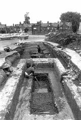 The 1993 trench measured some 14 m. by 3.50 m. with long axis set
north-west to south-east. The trench was cut to a maximum depth of 2.50m.
The natural watertable was reached at depth of about 1.70 m. and the
lower levels of the trench could only be examined with the aid of a
petrol driven water-pump. The base deposit across the entire trench
consisted of a flint river gravel which lay between + 5.85 m. and +6.06
m. O.D. The general sequence of deposits revealed was broadly the same
across the entire length of the trench, although a modern cellar had
destroyed the upper levels adjacent to St Peter's Lane. The cellar
represented an isolated structure and largely undisturbed soils could be
seen beyond it on all sides.
The 1993 trench measured some 14 m. by 3.50 m. with long axis set
north-west to south-east. The trench was cut to a maximum depth of 2.50m.
The natural watertable was reached at depth of about 1.70 m. and the
lower levels of the trench could only be examined with the aid of a
petrol driven water-pump. The base deposit across the entire trench
consisted of a flint river gravel which lay between + 5.85 m. and +6.06
m. O.D. The general sequence of deposits revealed was broadly the same
across the entire length of the trench, although a modern cellar had
destroyed the upper levels adjacent to St Peter's Lane. The cellar
represented an isolated structure and largely undisturbed soils could be
seen beyond it on all sides.
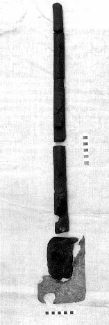 Due to the waterlogged nature of the deposits below the surface of the
peat it was only possible to excavate three small trenches in the base
of the main excavation in order to examine the underlying layers. The
sequence in each slot, however, was the same. Directly under the peat
was a fairly thin layer of light grey organic loam also fairly certainly
water-laid, which contained a significant amount of second- to
third-century Roman pottery and tile together with quantities of animal
bone and a small piece of Roman glass. Also from this layer were the
broken but substantially complete remains of an iron-shod wooden spade.
Although the iron shoes for such implements are well known on Roman
sites, the waterlogged conditions in the present trench have also led to
the preservation of the wooden blade and handle. The upper end of the
handle shows no evidence of a `T'- or `D'-shaped grip, having a simple
flat end. The angle of the fairly narrow blade to the handle indicates
that, at least in modern terms, this tool should be classed as a spade
rather than a shovel. The implement had a total length of about 1 in.,
the same as a modern example.
Due to the waterlogged nature of the deposits below the surface of the
peat it was only possible to excavate three small trenches in the base
of the main excavation in order to examine the underlying layers. The
sequence in each slot, however, was the same. Directly under the peat
was a fairly thin layer of light grey organic loam also fairly certainly
water-laid, which contained a significant amount of second- to
third-century Roman pottery and tile together with quantities of animal
bone and a small piece of Roman glass. Also from this layer were the
broken but substantially complete remains of an iron-shod wooden spade.
Although the iron shoes for such implements are well known on Roman
sites, the waterlogged conditions in the present trench have also led to
the preservation of the wooden blade and handle. The upper end of the
handle shows no evidence of a `T'- or `D'-shaped grip, having a simple
flat end. The angle of the fairly narrow blade to the handle indicates
that, at least in modern terms, this tool should be classed as a spade
rather than a shovel. The implement had a total length of about 1 in.,
the same as a modern example.
Peter Collinson Last change: 18th November 2018