 |
St. George's Gate
|
|
|
The continuing programme of road improvements by Kent County Council Highways Department which exposed Roman and medieval Ridingate in April 1986 ( Annual Reports 1985-6 13-14 and 1986-7, 34-5), gave us the opportunity to examine a further two gates interrupting the eastern defences of the city. Both excavations culminated in the laying out of the plans of the gates in brick set in the new road surface, as an enduring reminder of those lost city monuments. 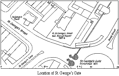 Our work at St George's Gate, which commenced in February 1988, was in two phases, each of approximately three week duration. Pressures on this busy carriageway precluded the complete exposure of gate fabric at one time, so each phase uncovered approximately half the gate. St George's or Newingate was probably the only major opening in the city walls not of Roman origin. The breaching of the Roman town defences to form an opening may have occurred in the late ninth or early tenth century, when the line of the present High Street was finally established as a main thoroughfare. Sections of Roman wall and rampart built in c. A.D. 270-90 were revealed during the progress of the excavation buried under later work. Mortar debris sandwiched between layers of dumped clay and soil, were evident in the rampart mass, indicating that wall and rampart construction were carried out simultaneously - an identical situation to that seen against Church Lane, St Radigund's (The Archaeology of Canterbury II, 82-5). Sealed beneath the rampart was a rich layer of Roman topsoil. The interface between this and the underlying brickearth displayed distinct shallow corrugations indicative of agricultural activity and the continuous use of the plough in this area before the city's defences were built. Fossilised within and buried by later work were remnants of an earlier gate. The clearest evidence for this was found under the carriageway at the front of the later gate. Here, on either side of the opening, set low down in the flanking late medieval towers were opposing Lower Greensand quoins indicating the presence of an earlier gateway, reused as footings for its successor. This early fabric, together with remnants of the north wall of a northem tower, within an intact sequence of levels inside the medieval northern tower, indicated an opening barely 7 ft. wide flanked perhaps on either side by narrow turrets projecting forward of and at right angles to the city wall. The early foundation within the drum tower was of laminated deposits of rammed chalk and flints, reminiscent of medieval construction methods rather than Anglo-Saxon. No datable finds were recovered from associated early stratigraphy, but a coin of Burgred, King of Mercia (852-874) was removed from soils infilling the Roman defensive ditch outside the gate. The presence of large pits, cutting the Roman wall, berm and inner edge of the defensive ditch south of the gate indicated that by the late twelfth century, this part of the city's defences was in considerable disrepair. Large quantities of iron working slag removed from the pits and adjacent ditch fills bear testimony to a phase of industrial activity outside the city wall at this time. The late fourteenth century saw considerable activity, repairing and rebuilding the northern and western city walls, including the construction of the Westgate and a number of wall towers, but documentary records indicate that major building works at Newingate did not occur until c. 1483 (see below) . The disrepair of the city defences in the twelfth century, taken together with the rammed chalk foundations for the early building and the late documentary date for further building works weight the arguments for early gate fabric being of medieval rather than Anglo-Saxon origin, but the evidence is equivocal.
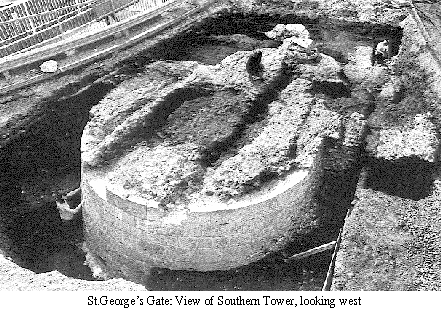
The fabric of St George's Gate (Newingate), though slighted to contemporary ground level, and mutilated by cellars and recent services, was spectacular. The beautifully cut battered ashlar skirts of Kentish ragstone, for both towers, still bearing tool and masons' (or quarry tally) marks, was admired by literally thousands of passers-by during the course of the excavation. St George's Gate was almost certainly modelled on Westgate, which was built in c. 1370-90 (The Archaeology of Canterbury 11, 118), substantially larger than St George's and at the time of its construction of up-to-date design. St George's Gate, probably constructed by 1495 (ibid., 22), was conservative in character, harking back to old fashioned military architecture, a century out-of-date. The massive gate towers of chalk block-work faced in flint and stone, flanked a narrow carriageway barely 7 ft. 6 in. wide, which was carried over the city ditch on a wooden drawbridge. Patches of road metalling survived between the supporting walls for the gate opening and carriageway vault. Though badly damaged by service trenches and a recent pedestrian underpass, sufficient fabric survived to establish the plan of the gate. This plan taken together with eighteenth century prints and drawings should enable a detailed reconstruction of the gate to be accomplished. The drawings show a portcullis protecting a two-leaf doorway. Above the gateway and three trefoil-headed niches and panels were machicolations. Access to the upper floors of the drum towers and gun loops was by a spiral stair set behind the southern drum tower. The foundation of this stair turret was uncovered during the excavation. After 1754 both drum towers were utilised as reservoirs for the
city's water supply and part of the city ditch south of the gate had
been infilled to make a new cattle market. Commercial pressures
following the establishment of the market and the construction
of a new road built outside the gate in 1790, led eventually to a
petitioning of the court of Burghmote by farmers and citizens to
have the gate pulled down. Accordingly on the 22nd April 1801,
it was agreed with 'deep regret' to take it down.
Go onto a report on the history of the gate.
|
Peter Collinson Last change: 18th November 2018