 |
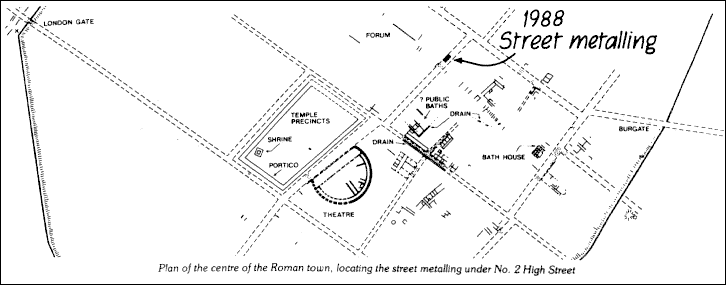
Roman Road at No 2 High Street
|
|
|
Structural repair works on the site of the former `Cheker of the Hope Inn', built for Christ Church Priory in 1392-5 (see Arch Cant. xxix (1911), 65), was preceded in October 1987 by the cutting of a trench in the basement of the property to locate a new stanchion base. Directly below sand bedding deposits for the original stone flagged cellar floor lay a sequence of gravel metallings for a major Roman street. The street. aligned north east to south west separated insulae containing the public baths to the south-east and Roman forum to the north-west. The gravel metallings were cut through by a brick built dome topped eighteenth century well. Removal of well lining indicated a total road thickness of c. 1.9m comprising numerous surfacings of compacted street metalling. The uppermost late Roman streets had been truncated during cellar formation in the late fourteenth century. Pre-Flavian samian recovered from leached redeposited brickearth underlying the primary street indicated a mid first century date for the first road. Our thanks are extended to George Oliver (Footwear) PLC for including time and funding for archaeological works in their development schedule.
|
Peter Collinson Last change: 18th November 2018