 |
No. 1O Best Lane
|
|
|
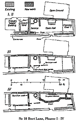
The discovery of a fine medieval crown-post roof at No.10 Best Lane in January 1988, set in train a sequence of events which saw not only the recording of surviving historic fabric, but a major excavation within the body of the building. Invicta Arts, who purchased the premises, formerly Kennard's Music Shop, intended completely to repair and enhance the surviving fabric, by stripping away recent structural and cosmetic additions, replacing elements long since removed and by lowering the ground floor. The surviving standing fabric was recorded by Rupert Austin at an early stage of the project (the diagrams are included on this page). The excavation of accumulated soils and floors within the body of the building was undertaken in two phases each of ten weeks duration. The present complex of buildings covering the site between Best Lane and the river comprise a street frontage timber-framed structure of late seventeenth century date, set long axis to the street frontage. A narrow range, set gable and on to this, with crown-post roof for three bays and the remains of original stone walls extends into the property block towards the river. A flimsy early twentieth century brick and timber structure continues the line of the narrow range to the river, with an extension of similar build and date covering former open ground possibly garden, to the south-west. A narrow lane opening onto Best Lane extends along the north-west side of the property block. A recent structure now covers the river-end of the lane. The excavations have concentrated in the area covered by the narrow range, its extension to the river and the former garden. The archaeological levels have been systematically removed and recorded to primary medieval floor level, which coincides with the proposed formation level for the new floor, a total depth of 1.60m. The earliest deposit so far encountered, in the sides of deeply cut features and under the primary medieval floor, were dark brown silty clays, partly dumped to counteract a rising water table and in part deposited by the river itself during episodes of flooding. These layers of unknown thickness, are below present water table and contain large quantities of domestic rubbish, including twelfth century pottery.
A substantial mortared flint and chalk wall, faced with flint on both sides, appears to have been constructed as a boundary wall against the north-east side of the property block. Contemporaneously was built a freestanding masonry structure with its north-west gable against the river. A door set midway along the new building's north-east wall gave onto an open hall with a fireplace of vertical peg tiles set in a bed of clay, contained by a chalk block-surround, sited opposite the doorway against the south-west wall. The `fireplace', recessed into the fabric of the wall, with traces of a fire-back of horizontal tiles and remnants of Caen stone jambs decorated with simple chamfers and brooch stops, was presumably covered by a hood surmounted by a lathe-and-plaster stack. The entire structure was probably of four bays length with the `open hall' occupying the two central bays. The eastern bay was separated by a wall extending to the centre of the structure. A chalk block and flint-lined well was located at the south-west end of the bay and an external garderobe or washing tank attached to the south-east wall, with connecting chalk block drain extending the length of the building to discharge in the river. The north-westernmost bay may have been overshot by a first floor containing a chamber, with the `open hall' extending under it. Laminated beaten earth and clay floors incorporating lenses of occupation detritus covered the primary floor of abraded mortar throughout the body of the building. Only in the south-east service area was a separate sequence of floors encountered The road frontage width; and depth of the earlier property block compares favourably with a Christ Church Priory rental for c.1200 (W. Urry Canterbury Under the Angevin Kings (1967) Map 2 Sheet 5). The land-holder at this time one Odo Spicier occupied a plot with a road frontage width of 22 ft. and depth of 102 ft. A further two property blocks of 68 ft. and 130 ft. width respectively occupied road frontage positions against Best Lane to the intersection with Waterlock Lane (now The Friars). The width of the stone building which may eventually have been extended to the Best Lane frontage measures approximately 21 ft. The depth of the present property block from street to river frontages still measures approximately 100 ft. Although an earlier rental for 1166 (Urry op. cit. Map 1 Sheet 3) indicates occupation by Lambert Gode at that time, ground plot dimensions are not given and property position is therefore less certain. The early sequence of soils under the primary building levels yielded a corpus of datable finds indicating occupation of the area from at least the mid twelfth century onwards, but no structural remains were in evidence. If buildings occupied by either Lambert Gode or Odo Spicier existed here, then they would have probably been sited against the unexcavated road frontage. Considerable modifications to, and an extension of the structure occurred in the late fourteenth century. The timber-framed building to the east was demolished and the narrow range extended over it for at least a further two bays and possibly to the road frontage. This extension to the northern dwelling and possibly a separate property beyond it may thus have been formed under a single roof. Only part of the extension fell within the excavated area. An internal door connecting the new extension to the stone house was located on the site of the garderobe, and new internal partition walls were built to contain the well in the service bay. A load-bearing wall of mortared chalk block-work appeared to have been a major division within the new arrangement, this underlying the second bay of the extension. A narrow passage with doors at either end was constructed against the north-east side of the extension. The new partition wall was presumably pierced by a door giving onto the large south-west room. Laminated clay and beaten earth floors formed throughout the building, with a separate and distinct sequence developing in each major division of the dwelling. Many repairs and modifications to the building were effected during this phase of occupation, including refurbishment of the fireplace base in the hall. A major episode of rebuilding probably occurred in the first half of the fifteenth century (Phase 4). Curious partition walls were constructed at the postulated high end of the hall against the river. These footings, containing separate floors served an unknown function. The load-bearing wall separating dwelling and extension was removed and replaced with a less substantial partition wall at this time. A new drain constructed of early yellow bricks (possibly made in the Sandwich area) capped by stone flags, extended from the wall in the service bay, across the hall to discharge in the river. New floors covered the fireplace in the hall and sealed the early sequence of deposits in the main room of the extension. Further modifications to the service area and extension occurred shortly after this. The longitudinal passage in the extension was removed and the connecting door blocked, thereby forming a single large room. A new door was opened mid way along the dividing wall between service bay and extension and a narrow passage giving onto the new door was created in the surviving service bay. Access to the well in the service area was presumably through a door in the new passage wall. The north-eastern half of the bay appears to have been within the body of the hall at this time perhaps containing a stair giving access to an upper chamber.
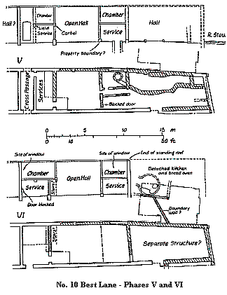
Substantial demolition deposits covering the early archaeological sequence so far described, mark the next phase of building development, this dating from perhaps the late fifteenth century. The main north-west wall of a new building overlay the hall/service partition (containing the well) of the earlier arrangement. The original roof certainly terminated at this point (the details for this termination survive), indicating that another roof covered a separate structure to the north-west against the river. Three bays of the crown-post roof still survive with evidence for a possible continuation of the roof to the Best Lane frontage. A lathe-and-plaster stud wall (which also exists) possibly separated a north-western first floor chamber from the open hall. Fabric from the main south-west wall of this possible chamber still stands with a window which may have been inserted at this time. The window was later enlarged and subsequently blocked. Tentative evidence for further modifications to the road frontage end of the building is indicated by the repositioning of the south-east wall of the hall, thereby reducing the size of the ground floor chamber. The size of this chamber would not have been viable and it is suggested therefore, that the through passage may have been blocked and incorporated into the new ground floor chamber arrangement. This possible increase in ground floor space may also have been reflected at first floor level. If this was the case then the door leading out into the garden area was either reduced in height or entirely blocked. Elements of a detached kitchen range, perhaps established during the later fifteenth century were uncovered in the garden area. Mortared flint and chalk dwarf walls for the timber-frame superstructure were exposed together with at least two phases of bread ovens. This service range may have continued function well into the seventeenth century. A sequence of garden loam together with a number of rubbish pits and the footing of a boundary wall separating the kitchen block from land against the river frontage were also recorded in this area. Of the building situated against the river frontage little can be deduced. Masonry foundations north-east of the earlier structure suggest that a completely new building set parallel to the river may have been constructed at this time. The late eighteenth century engraving of the Thomas Langdon map of the former Blackfriars area drawn in 1595 includes a representation of the building block. Langdon shows four separate building units; two narrow structures running gable to gable from Best Lane butting against a double range set parallel to the river. An apparent gap between the narrow ranges may mark the position of the passage opening onto the garden, mentioned above. The north-east end of the extant crown-post roof may coincide with the point of junction between the right angle ranges shown in the drawing, although there is some evidence to suggest that the narrow range continued to the river frontage with an extension built against its north-east side. Although one cannot place too much stress on the Langdon representation, it does offer one possible interpretation of the meagre archaeological evidence. The small bridge shown on the map crossing the river behind the property block is an additional interesting detail. This may indicate that the present lane continued under the river frontage range, perhaps through an open bay, giving access to the bridge and open ground beyond. The 1874 First Edition Ordnance Survey shows six cottages occupying the narrow property block, from the rear of the road frontage dwelling to the river. This arrangement, late though it is, may indicate that the river frontage buildings shown in the Langdon Survey and in part located during the excavation were set at right angles to each other, with the extension to the north-east being a free-standing addition covered by a separate roof. The separate building shown on the survey north-east of the cottages against the river may conceivably have been a surviving portion of the range. Elements of the cottage foundations were exposed during the excavation, together with a small brick-built boat dock in the former garden area. The conversion of the late medieval buildings to form early nineteenth century cottages and the earlier rebuilding of the road frontage structure effected in the late seventeenth century saw the removal of much earlier fabric Further elements of the medieval building were destroyed in the late nineteenth century when three of the cottages close to the river were demolished, and considerable damage to the entire building range was perpetrated when it was converted, and extended to form a garage shortly after the First World War. Despite these relatively recent episodes of vandalism No.10 Best Lane retains much of its medieval fabric. With careful repair and rebuilding it will make a fine addition to Canterbury's growing corpus of historic vernacular buildings. Documentary research for the property will hopefully be put in motion in the near future and a watching recording brief will be maintained by the Trust's field and building recording staff during the reconstruction work. Our grateful thanks are extended to Invicta Arts for allowing time and finance for the survey and excavation to take place.
|
 Remnants of an early timber-framed building were exposed
at the south-east end of the excavation under the point of
junction between the road frontage building and the narrow
range. Only the rear northern corner of the building was located
this of sleeper beam construction with a stone pad supporting the
principal load-bearing corner post. The walls were of clay build,
externally mortar rendered. Clay floors survived within the body
of the structure. Dwarf walls of mortared flint superceded the
ground beams, presumably underpinning timber framing. This
major repair, which also included refurbishment of internal floors
may have been associated with larger scale building works to the
rear of the property block.
Remnants of an early timber-framed building were exposed
at the south-east end of the excavation under the point of
junction between the road frontage building and the narrow
range. Only the rear northern corner of the building was located
this of sleeper beam construction with a stone pad supporting the
principal load-bearing corner post. The walls were of clay build,
externally mortar rendered. Clay floors survived within the body
of the structure. Dwarf walls of mortared flint superceded the
ground beams, presumably underpinning timber framing. This
major repair, which also included refurbishment of internal floors
may have been associated with larger scale building works to the
rear of the property block.
 Additional internal details can be deduced from surviving
elements of the south-west wall. A section of wall situated
immediately to the south-east of the excavated area was built up
in alternate courses of chalk blocks and flints. Fossilised within
this was the chopped end of a projecting door lintel chamfered
on both sides, a stone corbel set at the same height some way
to the north-west and a straight joint indicating the north-west
side of a possible through-passage doorway leading out into the
garden area. The south-east side of this passage may have been
the rear wall of an adjacent property fronting onto Best Lane.
These recorded details suggest that at least two similar and
adjacent dwellings were at this time covered by a single roof.
Each may have comprised an open hall of two bays extent, with a
single bay of two floors containing chambers, to the south-east.
In this arrangement the well may have been used by the
occupants of both properties. A third property certainly existed
in the unexcavated area between the cross passage and Best Lane.
Additional internal details can be deduced from surviving
elements of the south-west wall. A section of wall situated
immediately to the south-east of the excavated area was built up
in alternate courses of chalk blocks and flints. Fossilised within
this was the chopped end of a projecting door lintel chamfered
on both sides, a stone corbel set at the same height some way
to the north-west and a straight joint indicating the north-west
side of a possible through-passage doorway leading out into the
garden area. The south-east side of this passage may have been
the rear wall of an adjacent property fronting onto Best Lane.
These recorded details suggest that at least two similar and
adjacent dwellings were at this time covered by a single roof.
Each may have comprised an open hall of two bays extent, with a
single bay of two floors containing chambers, to the south-east.
In this arrangement the well may have been used by the
occupants of both properties. A third property certainly existed
in the unexcavated area between the cross passage and Best Lane.
Peter Collinson Last change: 18th November 2018